Overview
The Survey Locations module allows users to configure location levels, define a location level hierarchy, and upload a list of locations in which the survey is happening. Locations correspond to the geographical regions in which a survey takes place, like states and districts in India or provinces and counties in Kenya.Needed for features
- Assignments and Emails If location is included in the mapping criteria for surveyors or targets (as per Module Questionnaire inputs), location data is mandatory. In this case, locations are used to determine which field supervisor is in charge of which targets and surveyors for assignments and emails.
- Dashboards For both productivity and data quality dashboards, locations are required. They are an important dimension for aggregating, filtering, and sorting the data on the dashboard.
- Media Audits (Optional) Locations data is required if you plan to use the feature on media files to generate multiple Google Sheets - one per location.
Prerequisites
Finalize the locations for your survey (this is usually dependent on finalizing the sample) and prepare the locations dataset according to the requirements provided below.Configuration
Key concepts
Location level
Location level (also called geo level) is a geographic level within the sampling frame. E.g., the voter roll sampling frame in India has location levels -state,district,assembly constituency (ac)andpolling station (ps).
Location hierarchy
The location hierarchy describes how the location levels are related to one another. The location levels are expected to follow a 1:1 parent-child relationship where there is one topmost location level while every other location level is mapped to a single parent location level. Using the same example of the voter roll sampling frame, a group of polling stations is within an assembly constituency, a group of assembly constituencies is within a district, and a group of districts is within a state, which is the topmost location level in the hierarchy.
Prime geo level
This is the location level selected by the survey team as the level at which field supervisors operate. This is only applicable for data collection projects in which location is a mapping criteria. All field operation workflows like personnel mapping, target assignment, etc. are defined at this location level. E.g., if district is the prime geo level, a field supervisor is given charge of one or more districts - meaning all surveyors or targets working in that district are under their supervision.
Location
A location is a geographical region that has a name, unique identifier, and location level.
Datasets to prepare
Locations
Put together a csv file with location data that can be uploaded to SurveyStream. The data must meet the following requirements:- There are two columns per location level - one for the location unique identifier and the other for the location name. Hence, for the voter roll sampling frame discussed above with 4 location levels, the file would have eight columns.
- Both location ID and location name are non null and non empty for all rows.
- The data is at the level of the lowest location level, i.e., in the voter roll sampling frame, the data will have one row per
polling station. - A location defined by the location ID column cannot have multiple location names.
- The location IDs must be unique within a location level, i.e., there can’t be 2 districts with the same district ID. However, it is okay if the same IDs are used across location levels.
- A location cannot be assigned to multiple parents. E.g., in the voter roll sampling frame, if a polling station
P1is mapped to a districtD1and stateS1, another polling stationP2mapped to the same districtD1should also be mapped to the stateS1
Click to view a sample locations csv file.
Process
1
Add/edit location levels
On the Add/edit location levels tab, add the location levels relevant for the data collection.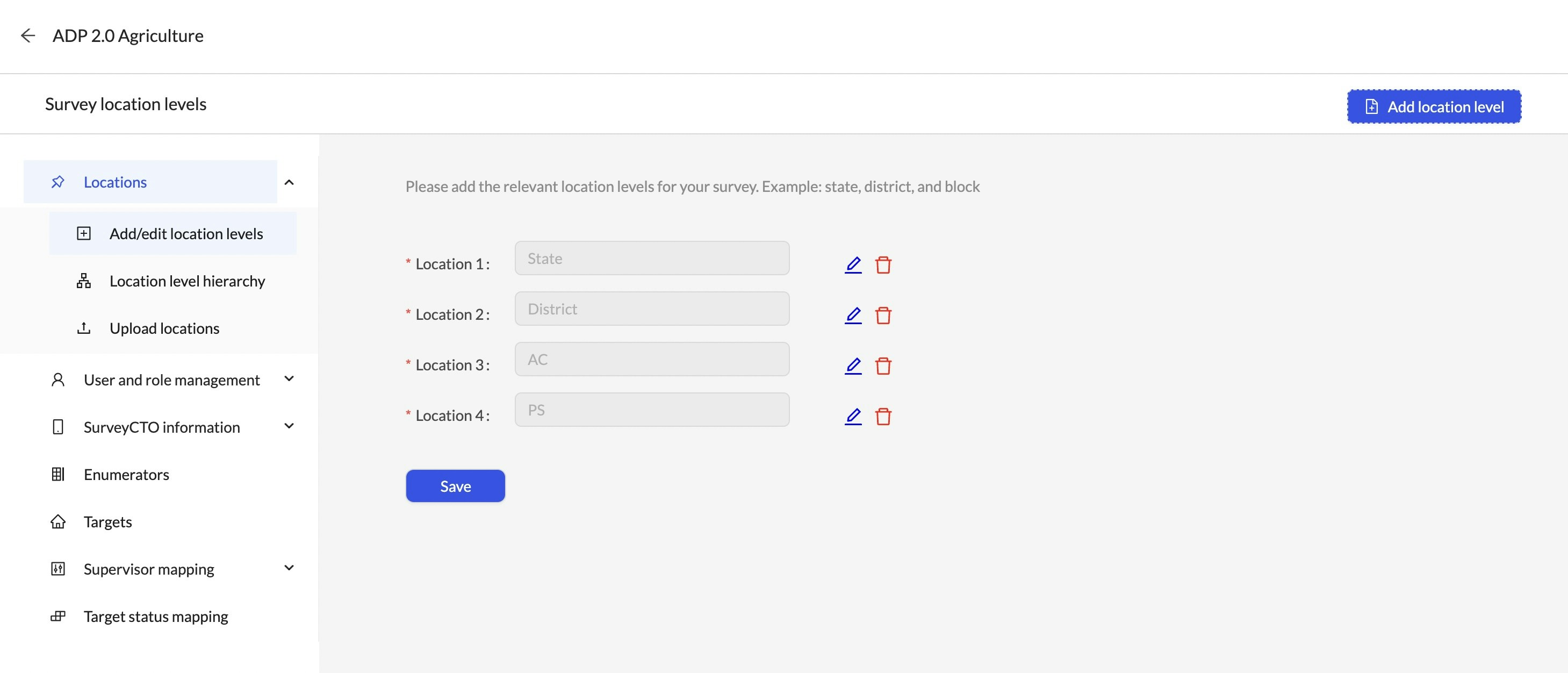
Even though there could be many location levels for the survey, on SurveyStream you only need to add the location levels that are relevant for the survey operations, for example the levels at which you wish to monitor productivity. Also note that each location level must have a corresponding variable in the SurveyCTO form.
2
Add/edit location level hierarchy
On the Location level hierarchy tab, define the hierarchy and the prime geo location.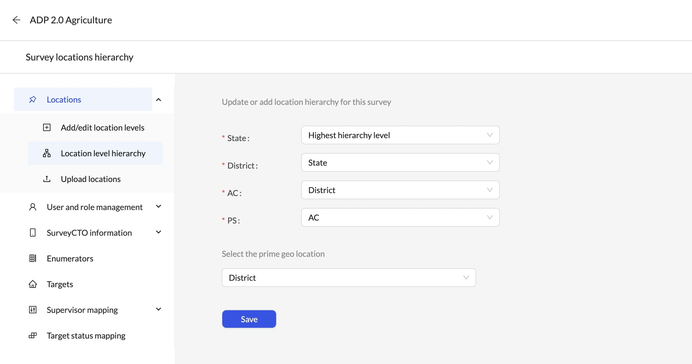
3
Upload locations
On the Upload locations tab, upload a csv file with the locations data as per the requirements provided here.
Walkthrough
Other actions on location levels
- Edit: Can be used to update the name of an existing location level
- Delete: If a location level was added by mistake or is no longer relevant, this action can be used to remove the location level
- Locations: If location levels are added/removed, any existing locations data will be removed and will need to be re-uploaded.
- Targets: If location levels are added/removed, the location column in the targets dataset (if present) is dropped. Users need to re-upload the targets to populate the location column.
- Enumerators: If location levels are added/removed, the location column in the enumerators dataset (if present) is dropped. Users need to re-upload the enumerators to populate the location column.
- SurveyCTO Integration: If a location level is added, users need to revisit the SurveyCTO question mapping screen to input the question mapped to the new location level.
Other actions on locations
-
Add: After the first upload, you can add more locations using one of the following two options:
-
I want to start fresh (Locations uploaded previously will be deleted)Use this action with caution since it will remove all existing locations data, replacing it with data in the csv file. Please note that if locations are re-uploaded using this option, downstream configuration steps like enumerators and targets will have to be re-uploaded (if already completed). -
I want to append new locations to the existing locations dataThis will add new locations in the csv file to SurveyStream. No changes are made to existing locations using this option.
-
- Edit: Can be used to update the name or mapping of an existing location
Errors in uploading locations
-
The file contains ... blank fields. Blank fields are not allowed...Check if any value in the uploaded csv file is empty. -
The file has ... duplicate rows. Duplicate rows are not allowed...Check if the file has any duplicate rows. -
The uploaded file has some rows that already exist in SurveyStream...This occurs if the append new locations option is used to add more locations. Check that the uploaded csv file does not have the locations already present on SurveyStream. -
Location type ... has location id's that are mapped to more than one parent location in column ...This occurs if a location ID that shows up in multiple rows (like a district ID in a polling station-level dataset) has different parent location ID’s in different rows. For example, a single district can show up on many rows but should belong to the same state in every row. To find the problematic rows, select the specified location ID column and the parent location ID column from the csv file, drop duplicates and find the rows that are duplicates only on location ID. -
Location type ... has location id's that have more than one location name.Check that the location ID to name mapping is unique for all locations in the specified location level. This means that a location can’t have more than one name across different rows where the location appears. To find the problematic rows, select only the specified location ID and location name column from the csv file, drop duplicates and find the rows that are duplicates only on location ID.